The oceans are turning
against the Pacific Islands
Climate change is rapidly reshaping a region that’s home to many cultures and diverse population. But will they be able to survive what's coming next?
Sea levels have surged ~103 mm since 1993, rising around 3.5mm annually. Island nations across the world face imminent submersion, demanding urgent global action before these communities are irreversibly lost to the ocean.

Vulnerable Pacific Islands bearing the brunt of it
Located in the Pacific Ocean, near Australia, these atoll nations are sovereign countries, made up mostly or entirely of low-lying ring-shaped coral islands surrounding central lagoons, having an average elevation <5m and are more susceptible to the changes and conditions.


Why are these islands one of the most vulnerable places to rising sea levels?
The extreme vulnerability stems from a unique combination of topography, geology, and oceanic positioning. Here are the key geographic factors that make these islands uniquely susceptible:
Extremely Low Topography and Relief
Coral atolls average just 1 to 2 meters in elevation, meaning there is no high ground for retreat. Because they are so flat, even a slight rise in sea level causes massive land loss.
Porous Coral Geology
The islands are formed from highly porous coral skeletons that act like a sponge. Traditional seawalls fail because floodwaters simply seep up directly through the ground from below.
Fragile Freshwater Lenses
Rainwater creates a fragile "freshwater lens" floating above denser underground saltwater, providing vital drinking and agricultural water. Rising seas and king tides push the saltwater upward, ruining wells and instantly killing crops.
Extreme Narrowness
(High Coastline-to-Landmass Ratio)
Atolls are incredibly narrow ribbons of land, meaning there is effectively no "inland" buffer. Because virtually all the land is coastal, storm surges can wash completely across the island, leaving communities and infrastructure totally exposed with nowhere to relocate.
Oceanic Isolation and Unrestricted Fetch
Sitting isolated in the vast Pacific, these islands face thousands of miles of open water, or "fetch," allowing winds to build massive ocean swells. As warming oceans degrade the surrounding coral reefs, the islands are losing the natural breakwaters that historically absorbed this devastating wave energy.
How these factors when clubbed with sea level rise, affect the islands
Representation of tide levels before and after sea level rise

King tides (perigean spring tides) are exceptionally high tides that occur naturally when the Earth, Moon, and Sun align closely, and moon is at its closest point to earth.
How the king tides form
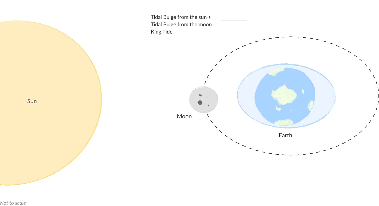
Historically, these islands could endure king tides. However, because the baseline sea level is now permanently higher (as shown in the 102.7mm rise since 1993), today's king tides launch from a higher starting point.
Let's take the cases of Tuvalu and Kiribati
The number of days where the tides were above the Mean Higher High Water (MMHW) level of 0.5m has increased significantly over the past few years, creating an unfavorable situation for the residents.
This rise in sea level and increased number of flooding days is making the wave-driven saline flood water seep and contaminate from the top as shown in the diagram below.


Then there's groundwater flooding too, exacerbating the situation for the inhabitants
These islands are made of highly porous coral skeletons that act like a sponge. Apart from waves just washing over the beaches, rising sea levels push saltwater up from beneath the ground, contaminating the freshwater lens — a source of drinking water and agriculture for the people.

This mixed water pushes from the bottom, makes its way through the ground and turns into sunny-day floods, as shown in the diagram below which poses issues in inhabited areas.

Groundwater flooding causes two other critical problems:
Destroys agriculture
Bypasses defenses: Traditional seawalls are entirely ineffective because they cannot stop water rising from under the ground.
Ultimately, groundwater flooding will likely make these islands uninhabitable due to a lack of food and fresh water long before they are completely submerged by the ocean.
NASA images show this region's vulnerability to the inundations

Funafuti, Tuvalu
Source: NASA

Betio, Tarawa, Kiribati
Source: NASA
All this has forced people to leave these pristine islands, for a better future for their families.
Source: World Bank
ABC News interviewed a Tuvaluan about the visa’s impact. She says she’s moving for her children’s future—not abandoning her country. Let’s hear how she feels:
Source: The Pacific, ABC News In-depth
The true severity of rising sea levels lies not in the final moment an island is completely submerged, but in the critical threshold of when it becomes uninhabitable. Long before the land disappears beneath the waves, the progressive loss of basic habitability, driven by contaminated freshwater, ruined agriculture, and relentless flooding, makes daily survival impossible.
This rapid loss of habitability inevitably leads to the loss of homes, ultimately culminating in the tragic and permanent displacement of entire island communities and cultures.
This project was created with love, for the Pacific Dataviz Challenge 2026.
The data source for each visualisation can be found below respective visualisations.